

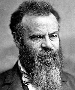
John Wesley Powell - The Father of Bioregionalism
John Wesley Powell was born on March 24, 1834, in Mount Morris, New York. In his early life, his family moved westward into Ohio, Illinois and Wisconsin, into what was then still a great frontier for most Americans. Powell served during the Civil War, and lost an arm at the Battle of Shiloh. Later in life he became a professor and organized expeditions to study the geology and natural history of the Western United States. His work led to the establishment of the United States Bureau of Reclamation, emphasizing community-oriented water management. I think his biography is worth your time, he was definitely an interesting guy. One of his most enduring contributions is the mapping of the watersheds of the American West.
In January of 1890, he testified to the Senate in Washington. He told the Senate Committee that the American West didn’t have enough water to support the kind of agriculture that was the norm East of the Mississippi river. The Senate was displeased to hear this news, as they wanted to settle and exploit the lands West of the Mississippi, as they had the lands East of it.
He presented to them this map:
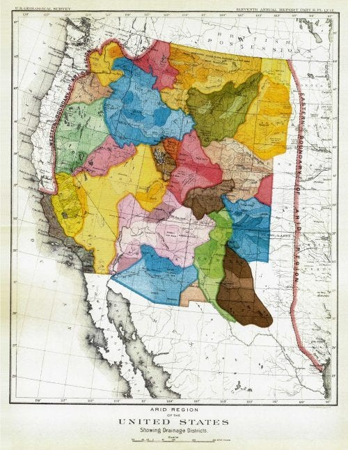
Arid Region of the United States
In this map, Powell organized the Western United States by watersheds.
A watershed is a land area that channels rainfall and snowmelt to creaks, streams, and rivers, and eventually to outflow points such as reservoirs, bays, and the ocean. The size of a watershed (also called a catchment or drainage basin) can be small or can encompass thousands of square miles. The Mississippi river watershed is the biggest in the US, as it drains 1.15 million square miles from 31 US states and two Canadian provinces.
Here is the Mississippi River watershed.
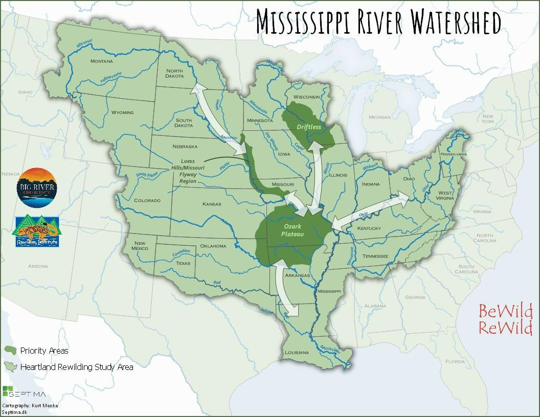
It takes up about half of the lower 48 in the United States. A drop of rain that falls in a river in Montana, Iowa, or Tennessee, all belongs to the Mississippi river watershed, and all ends up in the same place.
Powell’s map was the first ecological map, implicitly forcing us to see our land organized around the most fundamental of ecological lines - water; and not political lines of countries and states.
Powell envisioned that each watershed in his map could be its own state. His logic was that most people in the West made their livelihoods, or their lives depended on the watershed. So why not organize the people in those areas around those watersheds. The watershed was the most important common interest they had, so it made sense to organize them around it. Powell reasoned that laws and policies in each state should fundamentally flow from (no pun intended) the water, and ensure the ability of the water to serve the people that depended on it.
Instead, the Western United States is organized around latitude and longitude lines that make little sense other than they make the West into huge square blocks that it is easy enough for a child to draw. The American West wasn’t as easy to farm as the Great Plains and the East. The land was more arid, and nearly ⅔ of farmers in the West failed within five years.
Before Powell’s report, the prevailing wisdom about rainfall at the time was that “rain follows the plow.” Proponents of this line of thinking believed that plowing and cultivating land increased rainfall. This meant that the people that went to the American west in the 19th century - and were sent there by the US government to develop the land - thought that plowing the desert would bring the rain. That seems insane to us today, but it is what people believed at the time.
Not Powell. Powell cited empirical evidence of rainfall patterns in constructing his map, showing arid areas in which he strongly advised against agriculture. The Homestead Act of 1860 promised lang to any one willing to go out and settle it, but Powell warned that this would set settlers up for misery and failure if they happened to settle a plot of land unlikely to support crops.
Instead, Powell proposed that settlements consist of cooperative communities. Powell realized that there was safety in numbers, and that a community that could pool its resources and depend on each other, would have much better prospects than settlers each promised a square plot of land by the government, and told that plowing would bring the rain.
He proposed that collectives be able to create their own irrigation or grazing districts. The lands would be surveyed and classified primarily by the United States Geological Survey as irrigable lands, timber lands, pasturage lands, mineral lands, and coal lands. Interestingly, citizens would then democratically determine their own allotments and hold other individuals accountable to prevent fraud. It wouldn’t be some bureaucrat back in Washington that told citizens what to do, but the citizens themselves who worked and depended on the land, and each other.
Powell proposed that political borders be organized based on watershed boundaries, guaranteeing access to irrigation for the community rather than the individual allotment scheme that was eventually adopted and has led to waste and abuse of water resources. Importantly, Powell was adamant that water rights not be separated from land. This would guard against developers buying up land rights or water rights and using them to overpower the interests of citizens.
He lost the argument
In 1888 Congress appropriated funds for the Geological Survey under Powell to undertake a survey of irrigable lands and identify possible areas for dams and irrigation projects. With the same legislation, Congress also gave the Secretary of the Interior the ability to withdraw lands from the public domain, stating:
... all the lands made susceptible of irrigation by such reservoirs, ditches or canals are from this time henceforth hereby reserved from sale as the property of the United States, and shall not be subject after the passage of this act, to entry, settlement or occupation until further provided by law ...”
The US Congress, led by Senator William M. Stewart of Nevada imagined an expedition identifying potential sites for irrigation and then turning them over to private interests to develop. Powell disagreed, intended to create irrigation districts based on watersheds, invested in and governed by local communities, not by the federal government.
The survey or sights for reservoirs in the West had been commissioned by land speculators that were also part of the expedition. They wanted to stake their claim to the best land for future development. However, the Secretary of the Interior at the time responded to the survey by withdrawing all lands from the public domain - which did not please the speculators, Congress and the public who all expected the land to be developed.
The next year, the withdrawal of lands from the public domain was reversed by legislation and the budget for the US Geological Survey was cut. In 1894, Powell resigned as Director of the US Geological Survey, and his voice advocating for “bioregionalism” in the American West, went with him.
What could have been. What still could be.
Powell was far ahead of his time. Neither he nor the people of his time called him a bioregionalist, but that is what he was. He appreciated that we were of the land, water, and soil and should be connected to it through our communities in order to value it and safeguard it for future generations. He would have loved and helped lead the “bioregionalism” movement of today - recognizing that the best way to take care of the natural resources of a place is to let the people that know it, live in it, and depend on it, manage that resource.
Organizing “states” or at the very least, decision making power over local watersheds, at the local level is the core of what bioregionalism is all about. Powell realized that if we don’t understand and care for the land and the water we depend on for our survival, ultimately, we will not survive.
His ideas and his advice were largely ignored, and as a result ⅔ of farmers in the American West failed. They were set up to fail because science did not agree with the need to promise growth by those in power.
Sounds familiar.
It is fun to imagine what could have been if we had heeded Powell’s advice and organized the governing of the Western United States around nature’s patterns and not the short-term expediency of power politics.
Some may say that it is naive to assume that such a word could have existed, but such a world did exist for thousands of years. The people that lived in what is now the American West organized around these watersheds for millennia. Now we don’t. But in the future, we will organize around these natural rhythms of the water and land again. It is just a question of whether we do that by disaster or design.
John Wesley Powell was advocating organizing our society around the natural resources and rhythms of nature nearly 150 years ago … with one arm. Surely, it’s not too much for us to take up his cause today.
Fascinating! Thank you for educating us!
Hi Matt,
Great piece on Powell!
In the same vein, you'll probably be interested in this; https://www.life.earth
Cheers,
Frank